canyonwalker: My old '98 M3 convertible (road trip!)
This morning we set off on a road trip to Oakhurst. It's a jaunt of 175 miles, just a touch over 3 hours of driving without traffic. Having left at 9:47am (again, I mentally mark such things) I expected we could be hiking in the mountains above Oakhurst as soon as 1:30pm, after stops for lunch and probably gas along the way.

Just before we left, though, we heard the patter of rain on the roof. Not what we want to hear on a hiking day!

Rain on a road trip isn't much fun... especially when we're trying to go hiking! (Mar 2025)

Indeed it rained for the first leg of the trip as we drove south from Sunnyvale. There was no rain in the forecast for the area around Oakhurst... though the weather still wouldn't be nice there. The forecast has called for clouds and high temps in the 50s on Friday since, like, a week ago. "There's a week to go, maybe it'll get better," I said to Hawk. Hahaha, no, that didn't happen.

It's especially a pisser that we get partly crummy weather for our weekend trip after it was so nice last weekend when I was traveling for work. It was 72 on Sunday, 80 on Monday, and a whopping 85 on Tuesday— the warmest day since a freak heat wave 5½ months ago. But now that I have a day off it's not even 60. 😡

The Diablo Mountains are only green like this a few weeks a year (Mar 2025)

One thing about it being the rainy season in California is that many of the mountains that are brown most of the year are green right now. This is the Pacheco Pass (Route 152) through the Diablo Mountains. The East Bay Hills (also part of the Diablo range) in the Bay Area are carpeted with green right now, too. It's enjoyable to see it because it's only a few weeks a year these mountains are green.

The Diablo Mountains are only green like this a few weeks a year (Mar 2025)

Here's another pic of the incredible greenery. This is overlooking the San Luis Reservoir on the east side of the pass. And yes, the rain had abated as we passed through here.

The skies stayed partly sunny/partly cloudy as we drove across the Central Valley. The sun even started feeling a bit intense as we drove up into the Sierra foothills. Heavy clouds hung over the higher ridges of the Sierra, though. Would our hiking spot be favored with sun or it would be it cursed by those rain clouds? It seemed like it would be a close decision....

Stay tuned for more!

canyonwalker: My old '98 M3 convertible (cars)
It's been 5 weeks since we've done a Friday Night Halfway trip. The last one was to Jackson, California— and tonight we're in Jackson again! In fact it's not just Jackson we're staying in as our halfway point, but we're also headed tomorrow to the same all the way spot as 5 weeks ago. Tomorrow we'll drive up into the Carson Pass area of the Sierra Nevada mountains (which, BTW, are mostly in California, nephew) to hike to The Nipple again. Five weeks ago we only got partway there due to tough weather.

The drive out here was similar to last time. It's just 120 miles from home and it should have taken just over 2 hours to drive. Instead it took over 3 hours because of rush-hour traffic. Yeah, we knew we'd hit traffic snags leaving at 5pm. But I didn't sweat it because we were able to leave at 5pm. That's one of the nice things about working from home.... When we want to get out of town on a Friday night, we don't have to commute home from the office, then pack, then leave. We can throw together our bags during a short break (it doesn't take us more than about 10 minutes to pack for a simple overnight and a hiking day) and then leave when the workday's done.

This trip isn't exactly a do-over of 5 weeks ago. One thing that's different is we're staying in a different hotel. 😅  Tonight we're at a Holiday Inn Express instead of a Best Western. It's not that the BW was a bad hotel. I mean, okay, it did feel a bit slummy, but we've stayed in worse. But I would have stayed here again tonight— except that it was booked up!  And I wish that it wasn't, because when we arrived at the HIX just after 9pm it was in a blackout.

The front desk person explained that there was an accident nearby about 45 minutes earlier that knocked out power to about a quarter of this small town. Indeed we saw flashing lights of emergency vehicles a block down the road. We don't know when the power will be back on.

Thankfully the batteries on our devices are mostly charged. We have backup power banks, too. And since we've got our hiking gear, we've got dedicated flashlights as well. And at least the weather's neither oppressive nor chilly this evening, so we're fine without AC or heat.

Update, 10pm: The power came back on a few minutes ago. We'd been in the dark for about 40 minutes. Surprisingly it wasn't that bothersome. We just stretched out in the room with our electronics. The cell network was still working fine to provide us data.

canyonwalker: My old '98 M3 convertible (road trip!)
It's Friday night... and again it's Friday Night Halfway! Last Friday found us in Auburn, halfway to a hike in the Grouse Lakes Basin of Tahoe National Forest. Tonight we're in Jackson, halfway to a hike tomorrow along the Pacific Crest Trail above the Kit Carson Pass.

Jackson is a town in the foothills of the Sierra Nevada. It's a crossroads town, at the junction of highways 88 and 49. Route 88 is one of the passes over the Sierra Nevada. Route 49 is "the 49er trail" connecting a bunch of towns in the foothills that sprang up in the California Gold Rush that hit its peak in 1849 following the discovery of gold at Sutter's Mill the year before. Sutter's Mill is/was about 35 miles north of here, in Coloma, though in the gold rush years gold was discovered nearby here, too. In fact there are at least a dozen historical gold mines within a few miles of Jackson. But those are not why we're here. For us it's just Friday Night Halfway.

Not Stuck in Lodi Again

The drive out to Jackson starts like a drive to Yosemite. We leave the Bay Area via Livermore on I-580 the hook the short I-205 east toward Manteca. Yes, Manteca, the Spanish word for lard; lard as in rendered pig fat. But instead of going all the way to Manteca as we would en route to Yosemite, we turn north on I-5 to Stockton and cross over to Route 99 north. On Route 99 we drive north a few miles to Lodi to exit onto Route 88, which angles northeast up into the Sierra foothills.

Lodi is always an amusing town to drive through. We can't so much as think about the town without also thinking about the classic hard-luck song named for it.

Just about a year ago
I set out on the road
Seekin' my fame and fortune
Lookin' for a pot of gold
Thing got bad and things got worse
I guess you know the tune
Oh Lord, stuck in Lodi again

-- Creedence Clearwater Revival, "Lodi"

Thankfully we're not stuck in Lodi tonight, or even hanging our hats there. I mean, we could have chosen a hotel there. We actually did, once, ten years ago. Going back would have to be just for the LOLz, though, as Lodi is about as dreary in real life as it's made out to be in song. ...Not that Jackson is worlds apart. It's a hardscrabble town whose best days were upwards of 150 years ago. Stately Victorian buildings built as banks with Gold Rush money are today biker bars popular with 50+ year old rebels in MAGA hats. But at least Jackson's 30 minutes closer to where we're going hiking tomorrow.

canyonwalker: My old '98 M3 convertible (road trip!)
Here it is Friday night, in the summer, and once again we're halfway to somewhere else. 🎵 Woah, we're halfway there! 🎵

In a 1:1 this afternoon with my boss we were discussing weekend plans, and he said he finds it inspiring how much Hawk and I travel on weekends. I explained to him this Friday Night Halfway travel technique I started using years ago. The idea is simple: Drive a few hours on Friday night and stay in a hotel in some nondescript location to get a head start on going somewhere, typically in the mountains, Saturday. Use the extra time to do a fun thing on Saturday and get all the way home Saturday night so Sunday is an open day at home for rest, chores, etc.

If it seems like I've blogged Friday Night Halfway a lot recently it's because we've done it a lot recently— 4 times this summer, starting with one in June, and now 3 times in 3 weeks. This evening's trip is just in time, too, as it was just this morning that I finished blogging about these recent trips. 😂

So, where are we tonight? We're in Auburn, one of our usual suspects for Friday Night Halfway. It's a town in the foothills of the Sierra Nevada along I-80. We like it because it gives us a good jumping-off point for adventures up in the mountains.

Sometimes Auburn hotels get pricey, though, so maybe half the time we come through here we also stay down in the Central Valley, hanging our hats for the night in or around Sacramento instead. Tonight our usual haunt, the Holiday Inn, was expensive, but I found a good rate at a Best Western. We'll see what it's like staying at a lower-rung property... without elite status. 😱😂

The drive up to Auburn this evening was rough. I'm glad we were able to leave early. What would've been a 2.5 hour drive without traffic took closer to 4 hours of driving. Adding in stops for dinner and ice cream (yay!) we arrived at the hotel just before 9pm after leaving home at 4.

Tomorrow we'll drive up to the Grouse Lakes Basin, another common haunt. We visit that area for hiking generally at least once a year, sometimes twice. Why keep going back? So. Many. Lakes. It can still feel a bit repetitive, so we mix it up with different hiking routes. This time we're thinking of doing a peak climb we've never done before. We should be able to see lots of lakes from up there! And staying tonight in Auburn means we should have only an hour or so pleasant drive to the trail in the morning.

canyonwalker: Planes, Trains, and Automobiles. Travel! (planes trains and automobiles)
It's Friday night and time for another episode of Friday Night Halfway. Yes, we did a Friday Night Halfway just last Friday, driving to Redding. I haven't even finished blogging about the hiking we did on that trip, and already we're going on another one. But not back to Redding. Main reason: it's too smoky still from the Park Fire. 😧 🥵 Tonight we're in Fresno.

Fresno. Yes, Fresno. The 5th largest city in California. But we're not here because of its size or its significance... Fresno being widely known for its slogan, "No, really, we're now the 5th largest city in California." 🤣 We're here because it's halfway to somewhere else.

Somewhere else in this case is the Sierra National Forest and the Dinkey Lakes Wilderness. Yes, it's really called the Dinkey Lakes Wilderness. No, the lakes are not really dinky. I mean, some of them certainly are, but that's not why they have that name. It's a person's name. Yes, really. 🤣

This Friday Night Halfway is similar to a stay in Fresno 12 months ago. We're staying in a different hotel this time, so the last umpteen miles of the trip were the same. And it was only about 156 miles total from home. The Friday Night to Fresno Travelog I wrote last time still mostly pertains. At least this time we were able to get an early start from home, rolling out of our garage at 3:40pm, so were were all tucked away in our hotel room by 9pm after multiple stops for food, gas, and dessert, plus traffic delays getting out of the Bay Area.
canyonwalker: Sullivan, a male golden eagle at UC Davis Raptor Center (Golden Eagle)
The Park Fire continues to burn in northern California, north of Chico and east of Red Bluff. As of Sunday evening it has burned 386,000 acres. That's over 600 square miles. It is now the 5th largest fire in modern California history.

Here's a map of the fire as of this evening from CalFire (click on image for link to source page):

Park Fire as of 30-Jul-2024. Image courtesy of CalFire, www.fire.ca.gov.

The CalFire incident page for the Park Fire notes that there are over 5,700 personnel fighting this one fire. Firefighters are being pulled in from all over the state. When we were in Redding on Sunday afternoon, stopping for lunch while driving through, we chatted with a fire crew who'd just driven up from near where we live.

The size of the fire, at 386,000 acres as of this evening, hasn't grown much in the past 48 hours. Authorities say that's because the hot weather in the area that last through Friday broke on Saturday. With cooler temperatures and more humidity in the air, the fire has spread more slowly. This has also enabled crews to start containing it— though as of this evening it's still only 18% contained.

Miraculously there are no deaths reported from this fire. Thousands of people have had to evacuate homes, though. To their credit, and to the credit of authorities managing the situation, people were moved to safety quickly. I'm sure plenty of people in the areas impacted remember the tragedy of the 2018 fire that burned the town of Paradise. There, even a half day of "The fire can't possibly spread over here that fast!" meant that when evacuations orders did come, there was pandemonium and dozens of people died.

canyonwalker: Sullivan, a male golden eagle at UC Davis Raptor Center (Golden Eagle)
Sunday was the last day of our two-day weekend trip to the Trinity Alps in northern California. I'm backlogged on writing about the hiking we did over the weekend, but here I want to catch up on something else: the smoke from the massive Park Fire burning near Chico, California.

We started our day in Yreka, California. It's a town of about 3,000 people just 25 miles south of the Oregon border.

A deer strolls through the parking lot of our hotel in Yreka, California (Jul 2024)

The town's so small we spotted a deer strolling through the hotel parking lot when we were packing our car at 8:30am. But notice also in this picture how clear the sky is. Yreka is about 140 miles away from the Park Fire. Oh, and there are a lot of mountains in between them, too. Like 14,180' Mt. Shasta.

Southwest of Yreka the sky wasn't so clear. We headed down toward the Trinity Alps with a day of hiking planned, but as we got to Fort Jones, just 20 miles away, we could see a wall of smoke ahead of us. That wouldn't have been smoke from the Park Fire... it was smoke from various fires burning in southern Oregon. We decided to pull the plug on the Trinity Alps and try a pair of shorter hikes further south.

The "WEED" sign in downtown Weed, California (Jul 2024)

Our next stop was in Weed. Yes, there's a town called Weed, California, pop. 3,000. Yes, it's the one famous for the road signs "WEED: NEXT 3 EXITS".

Weed, Next 3 Exits! Road sign on I-5 near Weed, California (Jul 2024)

We did a hike about 15 miles northeast out of Weed. Down here the sky was clearer than in Fort Jones though not as clear as up in Yreka. There was haze low to the ground.

After that hike and driving back through Weed we continued south on I-5 toward home. Smoke in the air increased as we reached Lake Shasta. It got thicker as we dropped down out of the mountains into Redding, California, where we stopped for a late lunch. There we could not only smell all the smoke in the air but practically taste it.

Smoke from the Park Fire chokes the air around I-5 at Corning, California (Jul 2024)

Thick smoke continued with us quite a ways south of Redding. The last photo above is from near Corning, California. It's just before 4pm in the afternoon. You can see how thick the smoke is all around us and how it limits visibility. At this point we'd been driving through smoke for 80 miles— and would continue to see (and smell, and taste) it around us for another 70 miles or so.

Compare this to the smoke cloud we driving through here on Friday night. It was a single, if large, cloud on the horizon. On Sunday afternoon, less than 48 hours later, it stretched over 150 miles across.
canyonwalker: wiseguy (Default)
We started the day today in Redding, California, having driven here last night. On the drive up through the Central Valley we marveled at the smoke cloud rising miles high in the sky in the distance. It's from the Park Fire, which is burning near Chico. This morning there was another reminder of the fire still burning out of control:

Morning in Redding with the Park Fire burning to the east (Jul 2024)

This was the view out our window this morning. Surprisingly the air doesn't smell smoky. That means the smoke's not here yet; it's just forming a wall in the sky to the east of here. FWIW, if you turn around 180° the sky looks pretty normal. To the west there's blue sky, and you can see the mountains in the distance clearly.

The hotel was sold out last night. There are numerous fire crews staying here, not to mention people evacuating from east of here. I spoke to a woman over breakfast who spend most of the night driving back and forth to her house, grabbing as many things as she could stuff in her car each time as long as the police would let her in, and driving it to Redding to stash with friends.

BTW, the Park Fire has now grown to over 350,000 acres, making it one of the biggest fires in California state history.

canyonwalker: My old '98 M3 convertible (road trip!)
It's Friday night, and it's time for another episode of Friday Night Halfway. That's the term I coined for my approach of driving halfway to something we want to do far away on Saturday, on Friday night. It splits the time and effort of driving and gives us more time to do the thing we actually want to do on Saturday. I've been doing Friday Night Halfways for just over 9 years now. ...At least that's how long I've been blogging about it. I'm pretty sure I've actually been doing it for at least 12 years and more likely 15+.

Tonight's Friday Night Halfway brings us to Redding, California. It's a city of just under 100,000 population at the northern end of California's enormous Central Valley. It's the biggest city in northern California and a reasonable stopping off point for where we're going tomorrow: hiking in the Shasta-Trinity mountains west of Mt. Shasta, which is north of here. This is the almost-last minute trip we planned 48 hours ago.

How was the trip? I mean, the first half. 😅 The drive to Redding is just over 250 miles. Sans traffic and stops I could hammer through it in about 3h40m. But with Friday afternoon traffic and stops for dinner and gas it took us just over 5½ hours.


  • We pulled out of our garage at 3:30pm. I'd been hoping to hit the road earlier, at 3pm, but two afternoon work meetings got added to my calendar in the past 48 hours.

  • At least we were able to pack quickly so our leaving wasn't further delayed. It helps that we just need our hiking gear and changes of outdoors clothes for 2 days.

  • We fought through lots of traffic leaving the Bay Area. It took us just over 2 hours to get to Fairfield, where the Bay Area gives way to the Central Valley. Without traffic that part of the drive would take just a smidge over 1 hour.

  • We stopped for dinner in Fairfield. After that we only had traffic for about 5 more miles getting to Vacaville. Then, as we exited I-80 onto I-505, all the traffic melted away. For the next two hours it was just hammering across the plain of the Central Valley.

  • About that fire....

A huge smoke cloud from the Park Fire hangs over Chico, California in the distance (Jul 2024)

  • We saw this huge smoke cloud (photo above) from the Park Fire near Chico starting over 100 miles away.

  • Here in Redding it's HOT. It's not literally on fire, though you could be forgiven for thinking so with an afternoon high temperature of 102° today and smoke choking the air from the Park Fire east of here. By the time we arrived at 9pm the temperature was a still-warm 89° F.

  • We're staying tonight at a Holiday Inn hotel. I thought maybe we stayed here once before, years ago, but it turns out it's new to us. It's not a new hotel, though, but at least we've got a comfortable room. They thankfully left the A/C on for us so we didn't walk into a sweatbox.

canyonwalker: Uh-oh, physics (Wile E. Coyote)
Last night I booked a trip to go hiking in the mountains this weekend. Shortly after writing that blog this morning I checked my news feed and...

Aaand it's on fire 😧🔥😖

It's on fire.

Overnight the Park Fire near Chico, California exploded in size (Sacramento Bee article via Yahoo! News, 25 Jul 2024), growing from under 6,500 acres to over 45,000 acres by morning and 71,000 acres by midday. The fire was just 3% contained at last update in that article. That means it's burning out of control and growing in every direction simultaneously.

When smoke from a fire affected our day of hiking in the Sierras a few weeks ago I wrote that maybe we'll have to check not just the weather forecast but also the fire forecast before we travel. I wrote that as grim humor, not as a literal prediction! Alas my grim humor is the emerging grim reality. Summer in California is becoming fire season. Anywhere in the state may be burning or choking on smoke from a fire.

Fortunately the effects of the Park Fire are currently only indirect on where we planned to go hiking this weekend. Like the fire near Fresno a few weeks ago there will be dozens of miles and some pretty high mountains between it and us. But like then the smoke could be an issue. Already the smoke is definitely an issue in Redding, where we're stopping on our Friday Night Halfway. And it might be an issue up in the Shasta-Trinity mountains if the wind shifts strongly to the northwest (though that seems unlikely).

Incidentally this Park Fire is not far from Paradise, California, where the 2018 Camp Fire killed 85 people. (A note about naming fires: "Camp Fire" does not mean it was a campfire that got out of control. It was given that name because it started near a local road named Camp Creek Road.)

Update: this afternoon I saw news that authorities have arrested a man on suspicion of arson in deliberately starting the Park Fire! Example coverage: KCRA News Sacramento article, San Francisco Chronicle article. Witnesses say the suspect pushed a burning vehicle into a gully. So maybe it wasn't his intention to start a massive forest fire destroying numerous homes and requiring thousands of people to evacuate the area, but that's been the result so far of his deliberate actions.

Update 2: As of midday Friday, the fire has grown to 178,000 acres and is now rated as 0% contained.

Update 3: As of Friday evening, the fire has burned 239,000 acres. That's 373 square miles. 1,600 firefighters are working on it... and it's still 0% contained.

Update 4: As of Sunday morning, the fire has grown to over 350,000 acres. Cooler weather on Saturday slowed its spread and enabled firefighters to establish some containment lines, otherwise it could be even worse. Miraculously there are no deaths reported from this huge fire. Thousands of people have had to evacuate. To their credit and authorities' credit, people got moved to safety quickly. I'm sure plenty of people living in the area remember what happened in Paradise in 2018 when a half day of "wait and see" delays before evacuation orders came caused pandemonium and dozens of deaths.

Update 5
Tuesday check-in.


canyonwalker: Sullivan, a male golden eagle at UC Davis Raptor Center (Golden Eagle)
A bit over a week ago we made the decision to pull the plug on our July 4 hiking trip in the Shasta-Trinity mountains. The weather forecast was showing extreme heat over the 4 days we'd be there, and we decided it would spoil the enjoyment of hiking. Instead we stayed home— in the milder extreme heat Silicon Valley got— and had a great time lounging around the pool 4 afternoons in a row. But what did we miss? News reports yesterday provided some of the receipts.

From Friday through Sunday numerous heat records were set in California. In Sacramento, on-this-date records were set with 110° on Friday and 113° on Saturday. The Saturday high blew away the previous record of 105° set on July 6, 1989. In Redding a new all-time high temperature of 119° F (48.3° C) was recorded. New records were set in plenty of other cities, too.

Redding's record is directly relevant to what we missed because it's the closest larger city to the mountains where we would've gone hiking. Now, 119 in Redding doesn't mean it was 119 up in the mountains. As a rule of thumb, the air temperature drops 3 degrees Fahrenheit per 1,000 feet of elevation. Redding stands at around 600' elevation at the northern end of the Central Valley just below the Shasta-Trinity mountains. The hiking trails we were looking at had us starting at elevations of 5,500-6,500. So 15 to 18 degrees cooler than 119— yeah, still over 100. 🥵

canyonwalker: My old '98 M3 convertible (road trip!)
What comes after Friday Night Halfway? Well, Saturday Morning the Rest of the Way, of course! After we drove to Chowchilla on Friday night we finished up the drive to our true destination Saturday morning. The first of our true destinations, that is. Angel Falls.

Angel Falls in Sierra National Forest (Jun 2024)

This is just the first of many waterfalls at Angel Falls, a view we enjoyed seemingly just steps after starting the hike. More to come soon!

Getting to Angel Falls was easy this morning by virtual of having done our "Friday Night Halfway" thing. We intended to get up early, perhaps even at 6:30am, but set an alarm for 7 instead and then swatted the snooze button until almost 8. But that was okay because we didn't have hours to drive. We rolled from the hotel at 8:30am after pooh-pooing the crummy breakfast offered there.

We arrived in the town of Oakhurst about 75 minutes later. It was 48 miles of driving through the Central Valley at the Sierra foothills, plus a stop for gas in Coarsegold, where gas was ridiculously cheap (by California levels).

I mentioned last night that Chowchilla is small (by California levels) at 19,000 population. Oakhurst is even smaller, at about 13,000. But Oakhurst is a gateway town. Gateway towns are kind of like gateway drugs, except they're generally good for your health, not destructive. They're gateways to outdoor adventure!

In Oakhurst we stopped for breakfast at Jack in the Box. ...Yeah, it's low-brow, but Jack in Oakhurst is kind of a ritual for us. We also visited a knickknack shop in town but didn't buy anything because it was all junk. (Eating crummy food and shopping crummy junk stores are typical gateway-town activities, BTW.) After that we made the easy 15 minute drive up past Bass Lake to the trailhead for Angel Falls. We started the hike at 11am.

canyonwalker: My old '98 M3 convertible (road trip!)
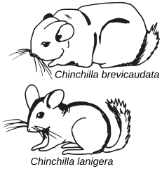
Tonight we're at a hotel in Chowchilla, California. No, not chinchilla. That's a species of rodent native to the Andes Mountains of Chile. Chowchilla. It's a town of approximately 19,000 people in California's Central Valley. By California standards that's basically a highway rest stop, though by New Zealand standards... it's twice the size of the towns of Clinton and Gore, combined.

Chinchillas
(image from Wikipedia article)
Why Chowchilla? It's Friday Night Halfway. We're headed to a couple of hikes in the Sierra National Forest tomorrow. Today's drive of 128 miles knocks out a few hours of travel, leaving us a drive of just 56 miles, about 1 hour 15 minutes, to our first hiking trail tomorrow.

We got stuck in some traffic driving to Chowchilla this evening. Normally it'd be a drive of just over 2 hours. Leaving at 4:45pm— which, yes, was less than 24 hours after I got home from a business trip 🥵— we caught a bit of early rush hour traffic driving south to Gilroy on US-101. We stopped for dinner in Gilroy wondering if maybe the traffic east through the Pacheco Pass might clear a bit but, alas, it didn't. We were stuck in the usual Friday Night Escape misery on CA-152. We'd lost almost an hour to traffic delays by the time we got to Los Banos. We stopped there for a bathroom break, leg stretch, and ice cream cones. Oof, I really needed the leg stretch. And the ice cream was good, too. 😂

Continuing east from Los Banos it was smooth sailing the last leg of the trip to Chowchilla. We arrived at our hotel at 8:45pm, for a trip of 4 hours including traffic and food stops.

What's in Chowchilla, other than approximately 19,000 people? Well, first of all, that 19,000 figure apparently includes the inmates in two area prisons. How many are free to leave their rooms in the morning like we will, I don't know. 😂

Chowchilla really is a highway rest-stop type of town. I mean, people do live here. We passed by many houses and a few apartment buildings on the drive in. It's an agricultural town. People who live here presumably work the farms in this area and the businesses that support them. And staff the two prisons. 😂 But the businesses in town are mostly gas stations and a few fast food restaurants clustered near highway 99.

Update: You know what happens after Friday Night Halfway, right? It's Saturday Morning the Rest of the Way!

canyonwalker: Planes, Trains, and Automobiles. Travel! (planes trains and automobiles)
I wrote in my previous blog about driving to Fresno on Friday night. It was more, though, than just "Leave home, drive 168 miles, 'You Have Arrived at Destination.'" The drive involves a number of legs of travel and points of interest that are so usual to me nowadays I often pass by them without even thinking. But what are they? Here are Five Things:

1. Gilroy
As we leave from Silicon Valley headed south on US 101 we traverse scattered ranchlands then pass through a few small cities at the south end of Santa Clara County. Gilroy, 40 miles from home, is the largest of these, with a population around 60,000. Billing itself "The Garlic Capital of the World" for the many garlic farms nearby and the garlic processing plant at the edge of town, it definitely smells of garlic. It's pungent enough with garlic aroma to make one's eyes water.

Friday night we intended to stop for dinner in Gilroy. In fact we actually did stop, but at the smell of not just pungent garlic but pungent cow manure (seriously, it smelled like roasted garlic plus an overfull port-a-potty on a hot day) we jumped back in the car and fled.

2. Casa de Fruta
We head east from Gilroy on state route 152, which crosses the rugged and surprisingly remote Diablo range mountains. At the foot of these mountains on the west side is a memorable oasis called Casa de Fruta. Taking its name from the style of the many fruit stands along route 152, where local farmers sell fresh produce cheap, Casa de Fruta is like a whole village dedicated to the idea. It's like the area's version of South of the Border or Wall Drug.

3. San Luis Reservoir
On the other side of the Diablo range, coming down from the Pachecho Pass, route 152 wraps around the shores of the San Luis Reservoir. It's a man-made lake, and it is huge. Or at least it seems huge, nestled in against the eastern flank of the mountains on one side and overlooking California's massive Central Valley on the other. One curiousity about San Luis Reservoir is that it does not catch runoff from the mountains. It actually stores water that is pumped uphill from canals in the Central Valley and redistributes back down to smooth out seasonal flows.

4. Los Banos and the rest of Route 152
A few miles after route 152 leaves San Luis Reservoir it crosses Interstate 5, then a few miles further east it passes through the town of Los Banos. Los Banos, "A Good Place to Take a Leak" (no, that's not really their town slogan). We're 90 miles from home when we stop in Los Banos, The Bathrooms in modern Spanish idiom, for dinner. This time we tried a hole-in-the-wall Mexican restaurant. Despite truly looking every inch a hole in the wall the food was surprisingly good.

Route 152 continues another 36 miles east of Los Banos to its junction with California route 99. This stretch of road is easily the most boring of the entire trip. It's just a dual ribbon of concrete cutting through farmland in the Central Valley.

5. Fly FAT?
There are a lot of things I could say about Fresno, many of them not flattering (like those I wrote in my previous blog. 😅 But what about fattering? Or fattening? This trip we drove around to the east side of Fresno where the airport is. The airport code is FAT. Its full official name is Fresno Yosemite International Airport. At less than 100 miles driving distance to Yosemite Valley it is the closest airport to the park.... But I've never seen anybody say that they're flying to FAT to visit Yosemite.


canyonwalker: My old '98 M3 convertible (cars)
Friday, 25 Aug 2026, 10pm. Fresno, California.

It's Friday night and we're in Fresno. Yes, that means it's Friday Night Halfway! Because why the hell else would anybody want to leave Silicon Valley to go to Fresno. 🤣


Maybe I shouldn't bust too hard on Fresno. It is the state's fifth most populous city. With a population of 550,000 it's ahead of Sacramento, the state capital; and Oakland. It's behind fourth-place San Francisco. But as basically an overgrown farm town iit is... miles away from San Francisco.

Speaking of miles, the drive this evening was about 168 miles. The map shows a timing estimate of 2:38 at off times. With traffic it took us about 30 minutes longer. Plus another 50-60 minutes for a dinner stop. All in, we were in our hotel by 10pm. Oh, and yeah, technically we're not in Fresno. We're in the adjoining town of Clovis, which I guess could be described as "Just as dismal as Fresno, but with even less to do."

Our plan for Saturday is to head east, up into the Sierra Nevada mountains. We've picked out a pair of waterfall trails to hike. With this head start from Friday Night Halfway we should have time to hike both of them!

Update: Keep reading in:

canyonwalker: My old '98 M3 convertible (cars)
Last night we drove to Folsom, California, halfway to Bassi Falls. Yes, that's the same as we did 6 weeks ago. We're doing it again! Why? Because six weeks ago we had to bail out early when Hawk got hurt. Plus, Bassi Falls is beautiful. It doesn't hurt to see it twice. And we'll finish the rest of the trip, with a few other hikes, we intended to do 6 weeks ago.

How much the same is it? Well, we started from the same place (we live there, duh), we're going to the same trailhead to start the day Saturday, and Friday night we stayed at the same hotel— almost. Instead of the Residence Inn we're at the Courtyard. They're both Marriotts and they're literally next to each other in the parking lot.


The drive out to Folsom Friday night wasn't bad. Driving 142 miles took us 3:15 including a stop for dinner of about 45 minutes. Oh, and speaking of the same trip as 6 weeks ago... we ate dinner at the same restaurant as last time. 😂 Though this time we left home 10-15 minutes later and made better time driving. We lost only 15-20 minutes to traffic. Thus we arrived 15 minutes earlier than last time.

You'll note driving 142 miles last night, with 202 shown as the total distance in the map above, is more than halfway. Yeah, that's because "Woooooah, we're halfway there!" is lyrical and "Wooooah we're 70.3% rounded up of the way there!" is not.

But back to things that are the same, or not. Last night after checking in we considered going to the same ice cream shop as last time. It was good! But this time I didn't quite feel like having ice cream; I wanted a beer or cocktail instead. Well, right next door to the Courtyard is a BevMo! It's, like, 50 feet from the hotel's side entrance. I grabbed a couple large cans of Negra Modelo (one for Friday night, one for Saturday) and took them back to the room to relax.

Final difference: we're getting an earlier leave on things this morning. We rolled from the hotel just after 7:30am and are now eating breakfast nearby— at the same restaurant (Del Taco) as last time! I hope that leaves us enough time to enjoy lots of outdoors stuff today. Of course, we'll have to avoid injuries while at it!

canyonwalker: Sullivan, a male golden eagle at UC Davis Raptor Center (Golden Eagle)
Yesterday I wrote about the idea of Universal Basic Income (UBI). I teased at the end that it's not just an idea, it's something that's been tried... if only on small scales. One of those experiments happened near me, in the city of Stockton, California.

The Stockton Economic Empowerment Demonstration (SEED) program ran from 2019-2021. It gave 125 residents $500/month for 24 months. Recipients were selected at random from neighborhoods at or below the city's median income. The cash was completely unconditional, with no strings attached and no work requirements.

What were the results? I summarize a few below; you're also welcome to read for yourself. Studies commissioned by Stockton are linked to at the program page above. In addition there was also a variety of reporting on the program. Examples include a March 2021 article in The Atlantic, an NPR News article from 3 Mar 2021, and a KQED News interview transcript from 23 Mar 2021.

Key findings I found important about SEED's experiment with UBI:

  • UBI increased recipients' earnings from wages. This completely refutes the standard canard of anti-welfare conservatives that pretty much any form of public assistance discourages work and simply promotes laziness and creates dependency. Program recipients used the $500/month stipend to bring stability to their lives that enabled them to seek higher paying, full time work instead of subsistence level, part-time jobs.

  • Recipients by and large did not use UBI money to buy alcohol, cigarettes, or drugs. Only 1% of the money tracked went to such things. The majority was spent on essentials such as food, rent, utilities, and transportation. This contradicted another standard anti-welfare canard that a poor person given a handout will just turn around to use it on drugs, tobacco, or booze instead of something productive.

  • Recipients enjoyed improved physical and mental health.

Great results. Now if only data could change people's minds....
canyonwalker: Sullivan, a male golden eagle at UC Davis Raptor Center (Golden Eagle)
On our drive to Barstow yesterday we took some detours across the Central Valley to avoid traffic slowdown. Our initial route plan was to drive I-5 from near Los Banos to Buttonwillow, then cross over to Bakersfield. Then I-5 crapped up, and real-time traffic apps recommended we drive 152 east from Los Banos to 99 then south. But then 99 crapped up, too. The maps suggested we drive a variety of county and local roads to avoid the jams. We're pretty bored with the two usual routes, so we figured, Sure, let's do it.

The roads took us through little bits of the Central Valley we've never seen before. For example, we finally saw the town of Firebaugh. We've only ever seen it by its name on road signs in the middle of nowhere. As in, "Firebaugh, 20 miles deeper into nowhere -->."

We also saw lots of hawks on the roadside. They were perched on telephone posts, power line pylons, lamp posts, etc.

We also saw lots of bird boxes. Most farms have them on near the edge of their orchards. Some of the mystery was revealed when we saw a big sign advertising Barn Owl enclosures. We passed a shop that builds & sells them. It was near Firebaugh. And right past that we saw another owl box... with a huge red-tail hawk sitting atop it.

Yeah, that's not going to attract owls. Think, a combination of "It's a trap!" and a riff on the signs you see for new housing/apartments... "If you lived here, you'd be dead already."
canyonwalker: Planes, Trains, and Automobiles. Travel! (planes trains and automobiles)
5 Days in the Desert travelog #1
Barstow - Fri, 23 Dec 2022, 9:30pm

This evening we arrived in Barstow. It's the first part of our journey 5 Days in the Desert (previous blog).

I wondered this morning if we'd leave home "on time". I was shooting for 10am but worried it might turn out to be 11... or later. I managed to be right on both counts! We actually left the house just after 10:00 but then we stopped at the REI in town because I needed another pair of hiking pants and a new flashlight. That wound up taking 'til 10:55 (I was quite irritated at how everything was slow) at which point we figured, we're here, we might as well have lunch. We ate at a favorite local joint in the same plaza as the REI. Then we got donuts at a favorite local donut shop in town. It wasn't until noon that we got more than 5 miles away from home.


Barstow is 382 miles away by the shortest reasonable route, with a driving time of about 6 hours when there's no traffic. Traffic looked clear early in the morning but then it crapped up by midday. Slowdowns and detours added almost an hour of driving time. With added stops for gas, dinner, and snacks we arrived in Barstow at 8pm.

So, how is Barstow? Understand that Barstow is basically a shit-hole. I don't think it's as much of a shit-hole as Bakersfield, which we passed through without stopping this time, but mostly that's because it doesn't pretend it's anything more than a highway rest stop town between LA/San Diego and Las Vegas. Oh, it's not literally just a rest stop. Barstow has a population of 25,000! But in California that's a small town.


canyonwalker: My old '98 M3 convertible (cars)
I finished my trek of I would fly 500 miles and I would drive 500 more on Sunday. We left the hotel in Bakersfield at 9am. It's 251 miles from there to my house. We split the drive with a stop for recharging and lunch at an oasis near Firebaugh on I-5.

The car got better mileage on Sunday. Partly that's due to less sweltering temperatures; they ranged between about 80-93° (27-35 C) in the Central Valley during our late-morning drive through there. And partly it's because we didn't drive as fast. Yes, I-5 is a long, straight road... but it's also crowded compared to I-15 and US-58 yesterday. With slow trucks and cars all over the places there isn't as much room to open the throttle.

At the charging stop I solidified my awareness of an emergent pattern among EV owners and their behavior at charging stations. It's a dichotomy that splits mostly along the lines of EV newcomers vs. EV grizzled veterans— which you can tell based on whether they're driving an EV that looks, say, at least 2 years old vs. one that looks relatively new.

  • For EV newcomers, recharging is a social event. When they hook up the charger they look around and are eager to chat with others about their vehicles and experiences. They're also conscientious about using the chargers. They pull into the spaces straight, and monitor their charge to pull out of the slot when they're done— so the next person can start charging.

  • The grizzled vets are the opposite of that. They pull in quickly and carelessly, often parking diagonally across two spaces. They connect the cables without acknowledging their neighbors. They leave their cars well past the time it takes to complete a charge, continuing to block multiple spaces that others could be using. You can't ask them to move because they're nowhere to be seen— for hours.

Every charging station we visited this weekend— and we visited four of them— had both types of people. And it aligned 100% with driving a new car vs. a slightly older one.

Profile

canyonwalker: wiseguy (Default)
canyonwalker

June 2025

S M T W T F S
1234567
891011121314
15161718192021
22232425262728
2930     

Syndicate

RSS Atom

Most Popular Tags

Style Credit

Expand Cut Tags

No cut tags
Page generated Jun. 2nd, 2025 05:35 am
Powered by Dreamwidth Studios
OSZAR »